United States
September 13 until October 19 2002
this page and the previous/following pages you will find a travelogue of the five week trip we made to Dallas and San Francisco, then we toured along a number of national parks in the southwest of the US with an RV and we ended our trip in Las Vegas. A this report is too long for one page it is split up into multiple pages. On this page you will find the second part.
- Part 1: September 13 until September 23.
- Part 2: September 24 until October 2.
- Part 3: October 2 until October 8.
- Part 4: October 9 until October 19.
Sequoia National Park
Sequoia facts and figures
In all the world, sequoias grow only on the west slope of the Sierra Nevada in California, between 1500 and 2100 meters. They are resistant to insects and fires. Forest fires are essential for their reproduction. The heat of the fire dries the cones and they will release their seeds. Also because of the fire, all dead wood on the ground has burned, leaving a fertile soil for the young seeds to germinate.Height: max. 100 meters
Age: max. 3200 years
Weight: max. 1200 tons
Bark: max. 80 cm
Branches: max. 2,5 meters
Base: max. 12 meters
The next day we drove from the unappealing campground in
Chowchilla into the direction of Sequoia NP. Via Fresno and Visalia we
went to the south entrance of the park. Our plan was to drive through the
park up north via the so-called Generals Highway. But there was an advise
not to use the south entrance with a vehicle longer than 22 feet as it
is a rather steep and winding road. Our RV is 25 feet in length so we decided
to turn around. Via Hwy. 245, which is also a very winding road, we drove
to the north entrance of the park. When we got into the park we decided
to stay at the Stoney Creek camping for the next night. On this campground
there are no hook-ups (water, electricity and sewer) so when we wanted
to use the microwave that evening we had to start the generator. At the
moment Arjan pressed the start button we were completely in the dark. Probably
a blown fuse. Luckily we had used the torch just before, so we knew were
it was on the table. Also the light in the cabin of the car was working,
that one uses the car battery , the living part (coach) of the camper has
its own coach battery and that one wasn't working anymore. We consulted
the camper manual to find out what to do. There had to be an (automatic)
40 ampere fuse somewhere with a switch to turn it back on. There were a
few options, under the bed, under the bench or under the bonnet of the
car. But we couldn't find it anywhere. In the meanwhile Ciska had start
crying because it was too dark for her and she wanted some light. Luckily
the fuse recovered after about 10 minutes and we had light again.
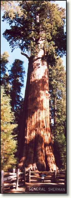
The next day we first went to see the General Sherman tree, the largest
tree in the world. It is not the highest tree, nor is it the thickest tree,
but it is the tree with the largest volume in the world. Its age is estimated
somewhere between 2200 and 2700 years! Next we walked a trail of about
3 km through the Giant Forest. Here you see numerous of these giants. Most
of them are more of less affected by fires, but forest fires are essential
for the reproduction of these giants. When we were almost at the end of
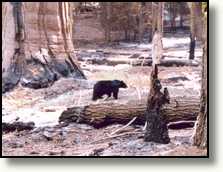
the trail, Hilleke suddenly saw a black bear in the woods, at a 30 meter
distance from us. Immediately we grabbed our cameras to snap this easy
strolling bear. We stood still very quietly, it doesn't happen that often
that you see a black bear in the wild. Ciska wanted to go there right away,
but we didn't like the idea of that. And then she wanted to run away immediately,
also not a very good idea. The bear might think you're a running prey and
would probably come after you.
After this close encounter we visited the Giant Forest Museum, the have
a lot of information about sequoias on display, well worth the visit. From
the museum we went back over the Generals Highway and over the very winding
Scenic Byway 180 to the Kings Canyon NP. During this drive Ciska suddenly
said she had to vomit. So we stopped and gave her a pill and Hilleke was
sitting next to her with a towel to catch it all when she would start vomiting.
And so she did, but Hilleke caught it all in the towel. We stopped at the
Sentinel campground in Kings Canyon NP to stay for the night.
The next day we drove to the end of the Kings Canyon Scenic Byway and
there we had breakfast. After that we drove back to Fresno to do some shopping
at a supermarket. From there we drove north to Yosemite National Park.
We spent the night at an RV park in Oakhurst. This campground has hook-ups
and there is a dump station to empty the sewer tanks. Although the campsites
in the national parks are much nicer (and cheaper) they also offer less
amenities for the demanding camper.
Yosemite National Park

The next morning, it is now Friday, 27th of September, we woke up early and
after breakfast we drove to Fish Camp, not far from Oakhurst. Near Fish
Camp there is an old steam train of the Yosemite
Mountain Sugar Pine Railroad. These trains were used to transport the
logs of the trees to the sawmill. The train didn't run on coal but on oil
and the locomotive wasn't an ordinary steam engine but it was one of a
Shay type. The ride lasted about 20 minutes and then the train stopped
to refill the water and the passengers could get off of the train to walk
around. After that we drove back the same way we came. Back at the starting
point we wandered around in the small museum and from there on we walked
back to our RV and continued our journey towards Yosemite NP. In Yosemite
NP we stopped at a viewpoint and from there we moved on to Yosemite Village.
 At the visitors centre it turned out that all campgrounds were full. Only
one campground, way into the park, had some free campsites. We decided
to go to a campground in a small town near the entrance of the park, El
Portal. The rest of the park we will visit the next day.
At the visitors centre it turned out that all campgrounds were full. Only
one campground, way into the park, had some free campsites. We decided
to go to a campground in a small town near the entrance of the park, El
Portal. The rest of the park we will visit the next day. The RV park in El Portal had enough free spaces with hook-ups. The next day we went to
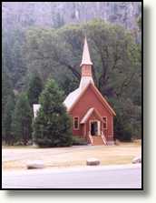
visit the famous Yosemite Falls. But first we visited the small Yosemite
chapel. From there we went on to the Lower Yosemite Falls. Unfortunately
there was not much water falling, only a small stream was dripping along
the rocks as the past summer was very warm with no rain at all.
The RV park in El Portal had enough free spaces with hook-ups. The next day we went to
visit the famous Yosemite Falls. But first we visited the small Yosemite
chapel. From there we went on to the Lower Yosemite Falls. Unfortunately
there was not much water falling, only a small stream was dripping along
the rocks as the past summer was very warm with no rain at all.
We quickly moved on to continue our journey. While we were riding on
Hwy. 120 the clouds became overcast. Then, in the mountains at an altitude
above 2 km, it suddenly started to rain. Not long after that it started
to hail, and not just a little bit. Within a minute or so, the road became
completely white. Hilleke was driving and wanted to stop at the next parking
lot to await the end of it. It is not much fun driving with mountains on
one side of a slippery road and a precipice on the other side. But before
we reached a parking lot, the hail had turned into snow. This was the first
rain this holiday. Now we also found out a new problem with the RV, next
to the non-functioning generator we also have a leaking cabin roof. Arjan,
on the passengers seat, felt some rain and even hail falling on him.
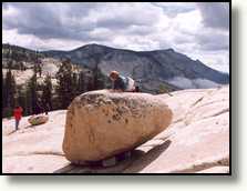 Our next stop was Olmsted Point, by the time we arrived there, it had stopped
snowing. From Olmsted Point you have a nice view over the Tenaya Canyon
and the Cathedral Range with Mount Lyell as its highest peak (3937 m).
From Olmsted Point we drove on to Tuolumne Meadows. There we refuelled,
not much as the petrol was very expensive, $2.= per gallon! We also had
lunch there. After lunch we went to the exit of Yosemite NP at the Tioga
Pass at 3031 m. From the exit we drove on Hwy. 395 to the north to the
visitors centre of Mono Lake. We only saw the lake from the visitors centre
as the rain was pouring from the sky. So we didn't see the famous tufas.
Maybe tomorrow. From the visitors centre we drove to an RV park in Bridgeport,
at the shores of Lake Bridgeport. On our way there the sky cleared up,
from the east we already saw a blue sky again. When we arrived at the campground
all was clear again. From our campground we saw the blue skies in the east
and the dark rainy clouds above the Sierra Nevada mountains. But is was
very cold at an altitude at more than 2 km above sea level. This evening
we used the heater of the RV for the first time.
Our next stop was Olmsted Point, by the time we arrived there, it had stopped
snowing. From Olmsted Point you have a nice view over the Tenaya Canyon
and the Cathedral Range with Mount Lyell as its highest peak (3937 m).
From Olmsted Point we drove on to Tuolumne Meadows. There we refuelled,
not much as the petrol was very expensive, $2.= per gallon! We also had
lunch there. After lunch we went to the exit of Yosemite NP at the Tioga
Pass at 3031 m. From the exit we drove on Hwy. 395 to the north to the
visitors centre of Mono Lake. We only saw the lake from the visitors centre
as the rain was pouring from the sky. So we didn't see the famous tufas.
Maybe tomorrow. From the visitors centre we drove to an RV park in Bridgeport,
at the shores of Lake Bridgeport. On our way there the sky cleared up,
from the east we already saw a blue sky again. When we arrived at the campground
all was clear again. From our campground we saw the blue skies in the east
and the dark rainy clouds above the Sierra Nevada mountains. But is was
very cold at an altitude at more than 2 km above sea level. This evening
we used the heater of the RV for the first time.
Bodie and Mono Lake
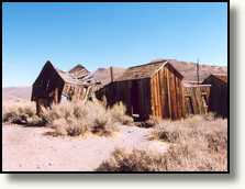
The next morning, after breakfast, we went to Bodie.
Via Hwy. 270, the last 3 miles of this road are unpaved. Despite the rain
of the last day this part of the road was not muddy.
 But the road was very bumpy, so everything we had in the camper rattled
and it seemed as if the RV would fall apart. But we made it. Bodie is an
abandoned mining town north-west of Yosemite. It is called after William
S. Bodey who founded this town in 1859 after he had discovered gold in
this area. After 20 years Bodie already had over 20,000 inhabitants. After
all gold was digged, most of the people left Bodie and about 50 years ago
the last one abandoned Bodie.
But the road was very bumpy, so everything we had in the camper rattled
and it seemed as if the RV would fall apart. But we made it. Bodie is an
abandoned mining town north-west of Yosemite. It is called after William
S. Bodey who founded this town in 1859 after he had discovered gold in
this area. After 20 years Bodie already had over 20,000 inhabitants. After
all gold was digged, most of the people left Bodie and about 50 years ago
the last one abandoned Bodie. Nowadays Bodie is a protected site, you are not allowed to take anything
from it, you even have to pay an entrance fee. The incredible amount of
$1.= for each person over 17 years of age.
Nowadays Bodie is a protected site, you are not allowed to take anything
from it, you even have to pay an entrance fee. The incredible amount of
$1.= for each person over 17 years of age. of the houses present in Bodie are left in state as when the residents
left. In some houses the plates and everything are still on the tables.
Some of the buildings are collapsed and they are left like that, some other
houses are supported to prevent further decay. Some of the houses you are
allowed to enter, the furniture covered by think layers of dust. In some
of the shops you may even find the merchandise from the old days. On several
places in the site you will find cars, also in a very decayed state. After
about 1.5 hours we left this interesting site and went back on the same
bumpy road. Next thing we had to find was a gas station as the meter was
very close to the 'E' of 'Empty'. We anticipated that it should be possible
to reach Lee Vining as that was in the direction of our next destination:
Mono Lake. Opposite the gas station, on the other side of the road, there
was a visitors info centre. There we asked how to reach the famous Mono
Lake tufas. The visitor info centre also had a few internet connected PCs,
so we were able to check our e-mail and to upload the next edition of our
travel report. Next to the visitor info centre there was a restaurant at
which we had diner. After dinner we went to the south side of Mono Lake via Hwy. 120 where the tufas are.
of the houses present in Bodie are left in state as when the residents
left. In some houses the plates and everything are still on the tables.
Some of the buildings are collapsed and they are left like that, some other
houses are supported to prevent further decay. Some of the houses you are
allowed to enter, the furniture covered by think layers of dust. In some
of the shops you may even find the merchandise from the old days. On several
places in the site you will find cars, also in a very decayed state. After
about 1.5 hours we left this interesting site and went back on the same
bumpy road. Next thing we had to find was a gas station as the meter was
very close to the 'E' of 'Empty'. We anticipated that it should be possible
to reach Lee Vining as that was in the direction of our next destination:
Mono Lake. Opposite the gas station, on the other side of the road, there
was a visitors info centre. There we asked how to reach the famous Mono
Lake tufas. The visitor info centre also had a few internet connected PCs,
so we were able to check our e-mail and to upload the next edition of our
travel report. Next to the visitor info centre there was a restaurant at
which we had diner. After dinner we went to the south side of Mono Lake via Hwy. 120 where the tufas are.
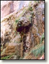
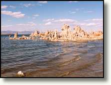 The tufa tower formations show what nature can do with a few basic elements.
The strange spires and knobs are formed when fresh water springs containing
calcium bubble up through the carbonate-rich lake water. The combining
of these waters forms calcium carbonate, a whitish limestone deposit that
forms the basis of the tufa formations. Its a bizarre sight seeing all
these towers in the water and on the shore. The tufas can only form under
water, but nowadays they are also on the land because the water level of
the lake has dropped in the past decades.
The tufa tower formations show what nature can do with a few basic elements.
The strange spires and knobs are formed when fresh water springs containing
calcium bubble up through the carbonate-rich lake water. The combining
of these waters forms calcium carbonate, a whitish limestone deposit that
forms the basis of the tufa formations. Its a bizarre sight seeing all
these towers in the water and on the shore. The tufas can only form under
water, but nowadays they are also on the land because the water level of
the lake has dropped in the past decades.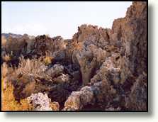 A lot of water from the streams that contribute to Mono Lake is re-routed
for the water supply of Los Angeles. The result of this is that less water
flows into the lake that the amount of water that evaporates, so the water
level drops. Near the lake there are also enormous amounts of Alkali flies.
They stay close to the water and at a first glance you may see it as a
kind of pollution. But when you get closer they all fly away. Ciska was
a bit frightened of all those flies around her legs, but they are harmless,
they don't sting. After we walked a trail along the tufas we left, in search
for a campground for the next night. As Cruise America didn't allow us
to enter Death Valley, as it is still too hot over there, we headed for
Zion NP in Utah, but that is a long distance from here.
A lot of water from the streams that contribute to Mono Lake is re-routed
for the water supply of Los Angeles. The result of this is that less water
flows into the lake that the amount of water that evaporates, so the water
level drops. Near the lake there are also enormous amounts of Alkali flies.
They stay close to the water and at a first glance you may see it as a
kind of pollution. But when you get closer they all fly away. Ciska was
a bit frightened of all those flies around her legs, but they are harmless,
they don't sting. After we walked a trail along the tufas we left, in search
for a campground for the next night. As Cruise America didn't allow us
to enter Death Valley, as it is still too hot over there, we headed for
Zion NP in Utah, but that is a long distance from here.
Straight across Nevada to Utah
We continued on Hwy. 120 to a town called Benton near the California -
Nevada border. There was an RV park, but it looked so neglected that we
move on on US Hwy. 6 to Nevada. We'll certainly pass a town that has a
campground on which we can spent the night. But there aren't that many
towns along the route. At first the road goes through rather mountainous
terrain, but when you passed these it becomes more flat and you end up
on those straight, long, endless roads in which you hardly encounter any
other traffic. The next place on our map was Coaldale, also the next place
along the road we saw. But you may hardly call it anything. Only a few
houses and a gas station, all abandoned and all windows were broken. So
we continued on Hwy. 6. The next town along this highway was Tonopah, another
41 miles on those endless roads. But the cruise control is ideal for these
kinds of roads. Tonopah is a somewhat larger town and Hilleke had found
an RV park in the Woodalls camping guide near a hotel. It turned out to
be one of the less appealing campgrounds we've seen. The park consists
of a number of lots behind a hotel, all with full hook-up. As it was only
for one night we didn't feel like searching any longer, Arjan had driven
for three hours in a row and it was also getting dark. The next morning
after breakfast, small pancakes, we first went to the supermarket to do
some shopping and we also went to the post office to buy some stamps for
the postcards. Also visited a gas station to refuel again, for a total
of $71.= it is completely filled now. From Tonopah we drove further on
Hwy. 6. Once again a dull endless road, now and then you pass another car
but most of the time you're all alone.
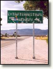
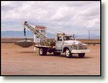 At the intersection with Hwy. 375 we continued on the latter one, also
called the Extra Terrestrial Highway as the road goes along a top secret military area (Area 51) and
one suspects that a lot of extra terrestrial stuff and live forms are stored
there. Also the most UFO sightings are reported in this area. Hwy. 375
is once again a long, dull road. The roads here are so dull that drivers
probably get bored. A lot of signs along the roads have bullet holes in them.
There is absolutely nothing to see, In the first and only town along this road, Rachel,
we stopped for lunch at the Little Ale Inn.
At the intersection with Hwy. 375 we continued on the latter one, also
called the Extra Terrestrial Highway as the road goes along a top secret military area (Area 51) and
one suspects that a lot of extra terrestrial stuff and live forms are stored
there. Also the most UFO sightings are reported in this area. Hwy. 375
is once again a long, dull road. The roads here are so dull that drivers
probably get bored. A lot of signs along the roads have bullet holes in them.
There is absolutely nothing to see, In the first and only town along this road, Rachel,
we stopped for lunch at the Little Ale Inn.
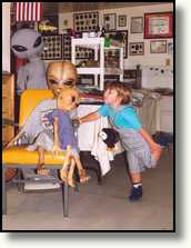 Everything here is related to aliens and ufos and you can
also buy there a lot of alien and ufo related souvenirs. From Rachel we
moved on to Caliente via Hwy. 93. We wanted to stay there at an RV park,
but when we saw that there was a railroad close to the campground we decided
to move on. On other nights we also stayed close to a railroad. And then,
when in the middle of the night one of these endless, slow moving, freight
trains passes, you are shaking in your beds for at least 10 minutes and they keep on blowing their horns.
Everything here is related to aliens and ufos and you can
also buy there a lot of alien and ufo related souvenirs. From Rachel we
moved on to Caliente via Hwy. 93. We wanted to stay there at an RV park,
but when we saw that there was a railroad close to the campground we decided
to move on. On other nights we also stayed close to a railroad. And then,
when in the middle of the night one of these endless, slow moving, freight
trains passes, you are shaking in your beds for at least 10 minutes and they keep on blowing their horns.
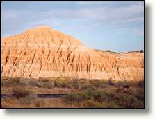 We headed into the direction of Panaca, we found a campground in the Cathedral
Gorge State Park. After a long time we are at a quiet again with a
lot of space. Only no hook-ups of course, so for electricity we are dependent
on the battery. So not too much lights else the carbon monoxide detector
starts with an irritating beep when the voltage drops too low. We experienced
this problem before and there is no way to turn it off. Arjan tried this
before but the only way to do this is to remove it from the wall and to
cut one of the power wires.
We headed into the direction of Panaca, we found a campground in the Cathedral
Gorge State Park. After a long time we are at a quiet again with a
lot of space. Only no hook-ups of course, so for electricity we are dependent
on the battery. So not too much lights else the carbon monoxide detector
starts with an irritating beep when the voltage drops too low. We experienced
this problem before and there is no way to turn it off. Arjan tried this
before but the only way to do this is to remove it from the wall and to
cut one of the power wires.
The next morning we woke up at around half past eight. The sky was
fairly cloudy today, only a few blue spots were visible. From Cathedral
Gorge State Park we drove back to Panaca and from there we went on to Utah
in the direction of Cedar City. Although the roads are also quite straight,
the environment is more beautiful. In the Nevada it was mainly a barren
desert, here in Utah is was much greener, the further we drove into Utah
the more greener it became. In Cedar City we stopped to eat something,
as we didn't had breakfast this morning. Here we also refuelled again,
the petrol is cheaper here, in the neighbourhood of the national parks
the petrol is more expensive. We had 33 gallon for around $50.=. Since
the previous refuelling we drove around 300 miles, meaning the RV uses
around 1 gallon per 9 miles (about 1 litre per 4 kilometres). The price
differences for petrol are quite remarkable, even between gas station opposite
each other. The largest price difference we saw was 30 dollar cents per
gallon. And then there are still people refuelling at the expensive gas
station, although you have to wait longer at the cheapest gas station.
So if you need refuelling it pays to drive up and down a town to find the
cheapest gas station, especially when you have to refuel an RV with lets
say 45 gallons of petrol. From Cedar City we drove via Interstate 15 to
the south and via Hwy. 17 and 9 to Zion NP.
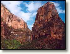
Zion National Park
On the way we had quite some rain and when we entered the park the rain
was pouring from the skies. After we had parked on the campground we went
to the visitors centre. We had plans to walk a short trail this afternoon,
but because of the rain we won't do any walking. From the visitors centre
we took the shuttle bus to see the park. At the first stop, at the museum,
we went off the bus. It's rather small and it tells you something about
the people that used to live in the park and the the pioneers that 'discovered'
the park in the beginning of the previous century. From the museum we took
the bus again to go to the end of road in the park, maybe the weather clears
up and are we able to do the Riverside trail.
 But when we arrived there the rain still poured down, so we decided to go back immediately. From
the bus we saw a number of climbers busy climbing the steep rocks of Zion
NP. Not much fun in this weather to dangle on a rope in the rain next to
a wet rock face. From what we can see from the bus, the park looks very
impressive with all the high rocks in a number of colours. Hopefully tomorrow
the weather is much better so we can see more of it. After dinner we went
to a slide show about the park. They show some slide about some of the
trails but also about the construction of the tunnel that connects the
Zion and Bryce Canyon National Parks. Tomorrow we will also go through
this tunnel when we go to Bryce Canyon NP. Today, when we entered the park,
we already had to pay a $10.= escort fee because as an RV we are an oversized
vehicle. The tunnel is so narrow and low that two RVs can't pass each other.
So when an RV wants to use the tunnel, all other traffic is halted and
the tunnel becomes one-way temporarily. In this way large RVs and buses
etc. can drive in the middle of the road.
But when we arrived there the rain still poured down, so we decided to go back immediately. From
the bus we saw a number of climbers busy climbing the steep rocks of Zion
NP. Not much fun in this weather to dangle on a rope in the rain next to
a wet rock face. From what we can see from the bus, the park looks very
impressive with all the high rocks in a number of colours. Hopefully tomorrow
the weather is much better so we can see more of it. After dinner we went
to a slide show about the park. They show some slide about some of the
trails but also about the construction of the tunnel that connects the
Zion and Bryce Canyon National Parks. Tomorrow we will also go through
this tunnel when we go to Bryce Canyon NP. Today, when we entered the park,
we already had to pay a $10.= escort fee because as an RV we are an oversized
vehicle. The tunnel is so narrow and low that two RVs can't pass each other.
So when an RV wants to use the tunnel, all other traffic is halted and
the tunnel becomes one-way temporarily. In this way large RVs and buses
etc. can drive in the middle of the road.
When we woke up the next morning, it was still raining. So there was
no use in walking a trail. The people in the park however did like the
rain as the past summer had been extremely dry, but we as tourists didn't
like it. So we decided to go to Bryce Canyon NP immediately. After breakfast
we first emptied the sewer tanks and refilled the clean water tank. Then
we went to the visitor centre to inform about the weather conditions in
Bryce Canyon NP. It turned out that there was snow above 7000 feet, but
the roads are up to 6000 feet, so that shouldn't pose us with any problems.
Walking back from the visitors centre we phoned our family in The Netherlands.
While on the phone it stopped raining and the sky started to clear and
in between the clouds some blue skies became visible. So we decided to
take the bus and go to the end of the valley and see if we could walk the
Riverside trail. The further we came, the more clouds disappeared. All
rocks became visible as first they were completely within the clouds. At
the end of the valley we got off the bus and we did the Riverside Walk.
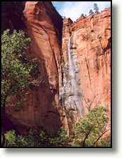
A trail of about 2 miles, there and back. Because of all the rain that
had fallen yesterday and last night a lot of waterfalls had appeared everywhere
in the park that normally aren't there.
 After the walk we took the shuttle back, and then also the skies became
overcast again. At Zion Lodge we got off the bus to eat. We could even
sit outside on the terrace. While we were eating it started to drizzle,
not much and soon it was over again. After lunch we took the shuttle back
to the visitors centre. In the mean time it became cloudy and it started
to rain again, so we had had much luck with the two hours of sunshine.
Back at the visitors centre we picked up the RV and moved on to Bryce Canyon
NP. The first part of the road is quite steep with a lot of switch backs.
Then there is the famous tunnel. On both sides there are rangers that are
in contact with each other. On the other side of the tunnel all traffic
was halted and we had to wait until the tunnel was clear. Then we could
drive through in the middle of the road as on the side tunnel there is
not enough clearance for our 12 feet high camper. When we came out of the
tunnel at the other side, the sun was shining brightly. But when we drove
on another camper approached us that had snow on it. Some moments later
we saw the snow at the roadside and even later there was also fresh snow
on the road. But that was only for a few hundred meters. Via Hwy. 89 we
drove up north, this road was still dry, there had not been any rain or
snow here yet. But the skies here also became darker and then it also started
to rain again. To our right we already saw the mountains of Bryce Canyon,
covered with sun lighted snow. A really awesome sight. Before we entered
Bryce Canyon we passed through the small Red Canyon with fire red rocks,
even more reddish than the rocks in Zion NP.
After the walk we took the shuttle back, and then also the skies became
overcast again. At Zion Lodge we got off the bus to eat. We could even
sit outside on the terrace. While we were eating it started to drizzle,
not much and soon it was over again. After lunch we took the shuttle back
to the visitors centre. In the mean time it became cloudy and it started
to rain again, so we had had much luck with the two hours of sunshine.
Back at the visitors centre we picked up the RV and moved on to Bryce Canyon
NP. The first part of the road is quite steep with a lot of switch backs.
Then there is the famous tunnel. On both sides there are rangers that are
in contact with each other. On the other side of the tunnel all traffic
was halted and we had to wait until the tunnel was clear. Then we could
drive through in the middle of the road as on the side tunnel there is
not enough clearance for our 12 feet high camper. When we came out of the
tunnel at the other side, the sun was shining brightly. But when we drove
on another camper approached us that had snow on it. Some moments later
we saw the snow at the roadside and even later there was also fresh snow
on the road. But that was only for a few hundred meters. Via Hwy. 89 we
drove up north, this road was still dry, there had not been any rain or
snow here yet. But the skies here also became darker and then it also started
to rain again. To our right we already saw the mountains of Bryce Canyon,
covered with sun lighted snow. A really awesome sight. Before we entered
Bryce Canyon we passed through the small Red Canyon with fire red rocks,
even more reddish than the rocks in Zion NP.